Author Archive | Justine Bourke

Kiandra to Kosciuszko – Diverted

29 December 2019 – 5 January 2020 Trip Report by Anne Turner – for joint SPAN OUTDOOR CLUB and NSW NORDIC SKI CLUB walk

In October I planned a New Year Snowy Mountains adventure walk. What about Paddy Pallin’s famous K2K route? Kiandra to Kosciuszko? After contacting SPAN Bushwalking Club and Nordic Ski Club I quickly got 3 willing partners in crime.

We studied maps and websites and John Chapman’s great Australian Alpine Walking Track (AAWT) book (which goes from south to north rather than north to south). We decided on seven nights, the last night camping just out of Dead Horse Gap, with a short walk the next day then drive to Thredbo for breakfast (proper breakfast, muesli would be banned!)

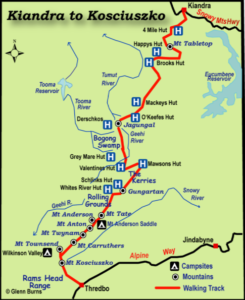
We would start at Kiandra and mostly follow the AAWT to Dead Horse Gap. After Mackay’s Hut we would go off track (a break from fire trails), around the eastern side of Jugungal along Bogong Creek and Jugungal Saddle then up Jagungal. We would then go south to Mawsons Hut, and camp near water somewhere. Then along the Kerries and to Gungartan, across to the Rolling Grounds over Consett Stephen Pass and along the main range finishing with Rams Heads. What a plan – I got excited every time we looked at the maps!

The weather looked clear but bushfires were a worry as it had been very hot and we were in an extended drought. We discussed whether or not to go and decided to proceed as the park was open and we would keep our wits about us.

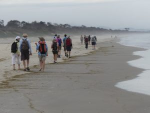
We didn’t have suitable car so would drive a hire car, leave it at Dead Horse Gap, and take a transfer from Dead Horse Gap to Kiandra on Sunday 29th December. We left Sydney on 28th December and on Sunday morning were on track by 11.30am walking towards 9 Mile Creek. There was water in the creeks which was good news. The march flies were around, not too bad at the beginning, but worse as it heated up.

Sue had given us a challenge to make up a limerick or haiku about each member of the walk. We were not particularly successful but there were some very funny conversations. The downsides were our heavy packs, overshooting 9 Mile Creek and walking up a horrible hill just to turn around and go straight back down. I’m not sure if singing ‘The Grand Old Duke of York’ helped anyone’s spirits at that point or not!

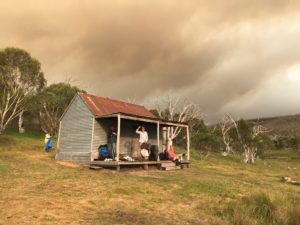
Day 2 saw us climbing Tabletop Mountain (sans packs) with the outline of Jagungal visible though smoke haze to the south. A pair of walkers we knew were going our way and joined our group. We got to Happy’s Hut in the afternoon and enjoyed its shady veranda while overhead was smoke and the red sun. During the afternoon we were joined by Catherine, walking solo, and later Ryan and his father in law Peter.

New Year’s Eve, 31 December 2019, was very warm and concerningly there were burnt leaves falling from the sky. While the sky overhead had a big billow of high smoke coming from the north east, the air around us was pretty clear. We decided to walk to Mackay’s Hut where we could exit the park if things deteriorated.

Catherine headed out before us and Ryan and Peter left shortly after us. As we walked on Tolbar Road and Grey Mare Fire Trail the light changed from clear to red then dark and at times there was a surreal brightness without shadows. The smoke cloud got bigger and darker and burnt leaves kept falling. We all started looking at each other and wondering if we were doing the right thing. We planned to walk past Mackay’s Hut to O’Keefes Hut and access Farm Ridge or Round Mountain fire trails if necessary.

As we rested Catherine came striding towards us having turned around after making contact with the outside world at a high point. She told us that there were fires to the west of us and Bega was on fire. She had decided it was time to go east and not leave it until things went wrong and she become a burden on emergency services. As we had been considering the same thing we quickly decided to join her.

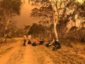
We walked back to the Grey Mare Trail and Tolbar Road crossroads and the sky kept getting darker with occasional rain showers, an eerie silence and smoke haze affecting visibility. After we had been walking for about 30 minutes we ran into Ryan and Peter.

We drew heavily on Catherine’s local knowledge of the park as we discussed our options and looked at maps. Walking back towards Kiandra to Broken Dam Hut then to the highway was one option but it would take us north west towards the smoke cloud so we decided against it. We decided to go down to Eucumbene Cove was too far and instead settled on walking north east down the Tolbar Road to Providence Portal (a little cabin community on the northern arm of Lake Eucumbene). It was close to Adaminaby and we thought it should have people there and up to date information.

The afternoon was now cool and breezy – nice walking weather if there had not been a raging bushfire nearby! We had enough rain at two points for raincoats and rolling thunder all afternoon. We heard a chopper at one point but we were in trees so couldn’t see it and it couldn’t see us. We saw a burst of new smoke on the skyline behind us and to the north and another way south of us. It must be lightning strikes we theorised and were glad to be getting out of there.

We walked about 35kms on our third and final day. Fortunately the end of Lake Eucumbene wasn’t a lake anymore as there was not enough water. Peter gave us directions and the river was so shallow and divided into tributaries that we would be able to easily wade across. This was great news as none as us had enough in the tank to do the huge walk around. It was a beautiful flood plain with lots of birds, kangaroos and white daisies. We all breathed a sigh of relief as the cabins of Providence Portal grew closer.

At about 7.30pm we were greeted by the park owner Hans riding out on his quad bike greeting us with ‘Where the bloody hell did you guys come from?’ We discovered the SES had evacuated the park an hour before. Hans got on the blower and we overheard him saying, ‘I’ve got 9 walkers that have just walked out of the bush – what am I going to do with them?’ He didn’t get an answer immediately, so we camped there the night.

We woke up to a plan. Some park residents and Hans would drive us to Adaminaby. It was New Year’s Day and the town was deserted.  We then managed to get rides to Cooma evacuation centre. Ryan and Peter got a ride from Cooma back to Wagga with a friend.

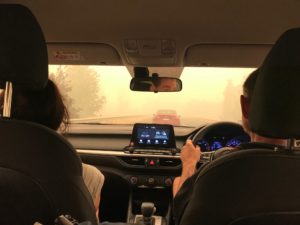
Cooma was very busy with lots of smoke and traffic as everyone holidaying south of Bateman’s Bay were leaving the fire zones through Cooma.

Catherine had organised for our drivers to be taken to the cars so they could collect the rest of us. Finally at 5pm we left Cooma and got back to Sydney around 11.30pm relieved to see home and a bed.

Today, the 9th January 2020, Fires Near Me advises the fires have cut through the northern section of the park – the area we were walking. Happy’s Hut looks like it is gone, the historic Kiandra Court House is gone and Providence Portal is surrounded by fire. Watching the horror of the fires spread over the coast and alpine areas we are so glad to be out. I was very glad to be with a calm level headed group who carefully considered the situation and our options and pooled their knowledge – thank you Catherine, Phil, Sonia, Sue, Paul, Sandra, Ryan and Peter.

Some other points we reflected on afterwards:

  • The superior phone coverage of Telstra in isolated areas
  • Between the group of 9 we had 4 PLBs
  • The Roof Top Map gave us a bigger area in one view than looking at several toppos to make decisions
  • Our phone batteries ran out – write your key phone numbers, personal and things like SES and National Parks down in your first aid kit
  • Ryan had a battery pack to refresh his phone – a weight consideration, but very useful
  • Where we had signal, we used Telstra phones to let contacts and the SPAN president know we were OK and what our plan was. We also contacted National Parks with the same news and told them where our cars were so they were not concerned for their owners. And then of course we followed up once we were ‘out’.
  • Next time I would lodge a National Parks Trip Intention form. While it isn’t a requirement, it would have helped.

Bushfire in Gondwanan Rainforests

2019 Fire in Nightcap National Park – A summary of Dr Robert M Kooyman’s talk at Wilsons Creek Hall, 23 January 2020

See below for videos of Dr Kooyman’s talk

Rainforests contain 40 million years of evolutionary history with a range of plant and animal lineages and communities with origins in Gondwana. The ancient supercontinent Gondwana broke up approximately 180 million years ago and as Australia drifted away from Antarctica, rainforests contracted to its east coast and far north. Only 1 percent of the original 40 million year old Gondwanan rainforest survives in Australia. Read more.

Australia has the most diversity of remaining plant and animal lineages with Gondwanan histories. The Gondwana Rainforests of Australia are world heritage listed in recognition of their unique landforms, species diversity and role in demonstrating the development of life on earth. Read more.

In particular, the Nightcap National Park (NP) area contains many plant and animal lineages with Gondwanan histories, including many threatened species.

The scale of the November 2019 fire event in the Nightcap NP was unprecedented and catastrophic. Historical logging activities in the Nightcap area up until 40 years ago resulted in the loss of 90 percent of old growth trees. Of the remaining 10 percent, the bushfires have caused the loss of a further 10 to 30 percent of old growth trees.

Historical logging activities increased forest vulnerability to fire as flammable eucalyptus components were accentuated at the cost of fire resistant rainforest species. On eucalypt ridges smaller re‑growth trees, such as blackbutt or Eucalyptus pilularis, growing close together with crowns touching enhanced the spread of canopy fire.  Shrubs growing on the forest floor due to increased light penetrating the canopy were dried out by drought and promoted fire through the understory. Logging debris pushed into the rainforest and increased fire heat and penetration into rainforest.

Recovery of the Nightcap area ecosystem is likely to take hundreds of years. A total of 16 plant and 27 animal threatened species were affected by the fire. Tragically, approximately 25 to 30 percent of the critically endangered Nightcap Oak species was lost to fire. The endangered peach myrtle species were also affected. Brushbox and palm forest species were burnt at Terania Creek.

There are signs of recovery in the eucalyptus forests as these species are fire adapted. The eucalyptus ridgelines are re-sprouting and acacias have re-seeded. However rainforest species are not fire adapted and it is likely that some will continue to die due to the stress of the fire event. Lowland rainforest was less affected by the fire than upland rainforest. The Mt Nardi rainforest was sprayed with fire retardant and is likely to recover as there are signs of re‑growth.

Fire resistance of the forest would have been enhanced if more rainforest had been preserved by the Forestry Commission given that rainforest species resist fire. Future planning policy should incorporate planting fire resistant rainforest species near houses/communities as a barrier to fire.

See below videos of Dr Kooyman’s talk including an earlier video of Dr Kooyman discussing Gondwanan rainforest.

Dr Rob Kooyman on the forest fires…Part 1.

Rob Kooyman (forest ecologist extraordinaire) takes us through what we've lost and what we can learn from the recent bushfires that ravaged Australia's forest whose evolutionary history goes back more than 100million years when Gondwanaland (mainland Australia) was still attached to Patagonia (current day Chile and Argentina) and the Antartica. Today's 8min clip relates to northern NSW where Rob lives and has done much of his field work from his earliest days as a forest ecologist 40 years ago (though not exclusively – Rob's in demand all over the world for forest regen and advise on how Govts from Madagascar to Kalimantan can best manage their forests). We'll be posting several more clips over next few days of Rob's talk at Wilsons Creek this week. So those who didn't make it or don't live in the area can learn from what Rob has to offer.

Posted by Frontline Films on Saturday, 25 January 2020


Rob Kooyman's Bushfire talk Wilsons Creek Hall conts.

'Doctor Rob' continues his talk from last Thursday night at Wilsons Creek Hall about the state of health in the forests of northern NSW and Australia generally post the Bushfires. Please share with your friends and those True Believers who know this has come about in part because of Government (both major parties…) inepitude in not tackling Climate Emergency as the real War of Terror bearing down on us all.

Posted by Frontline Films on Monday, 27 January 2020

Rob Kooyman's talk post Bushfires Part 3

I have nothing but the highest respect for Dailan Pugh's forest activism (which he was honoured with an OAM from Queenie Liz some years ago…) and long time koala lover (a key indicator species of forest health … just one of many animals and birds Dailan has fought for in the forests for over 40 years). Dailan has just written a note alerting us to the latest scam by loggers and the timber industry's greedy operators (eg Boral) who only view the forest as a resource to harvest and make money from. They are now using the pretext of 'salvaging' millions of tonnes of timber slightly burnt or badly burnt in the recent fires in Victoria and NSW to get into their with their industrial juggernaut machines that allow them in one coup alone to cut and truck upto 600 logs a day. We have to STOP this lunacy from happening, particularly after the fires. Otherwise we, our kids and grandkids are cactus because we ALL rely on healthy forests (which they hardly are any more…) for clean water, air and biodiversity. You all know the Rub and truth to that. As Rob Kooyman continues to outline in the video below. Dailan writes: "The tip is that there is going to be a press release (soon) …announcing an intent to introduce legislation to allow salvage and 'hazard reduction' logging in national parks. If correct, I imagine this is only part of a suite of measures that will herald an all-out assault on our national parks. The National Party's cherished aim of opening up National Parks to logging and grazing seems to have borne fruit in the midst of this environmental catastrophe. If correct, its important that as many people as possible make an immediate outcry.Dailan.

Posted by Frontline Films on Tuesday, 28 January 2020

Dr Rob Kooyman continues his talk on impact of Bushfires

Finally…Hopefully this clip holds Sync and Sound. In this clip, Rob Kooyman asks if we should start planting more rainforest deliberately, strategically as a buffer to future fires? Given his observations of what took place in the rainforests of the Nightcap Range and elsewhere on the east cost. “We saw in these last fires on the Nightcap how rainforest resists fire. The rainforest in one spot actually stopped the fire. If Forestry hadn’t increased the area of eucalypt forest, we’d have had a different outcome,” says Rob. The opposing idea put by our Prime Minister and others is we might consider clearing more, burning more, logging more…and using that as part of our carbon accounting..!

Posted by Frontline Films on Sunday, 2 February 2020

Rob Kooyman Clip 2 – Dangers in Paradise.

I recorded this interview with Rob Kooyman a year ago. Twelve months before the greatest disaster that has hit our forests in the recent bushfires. In the aftermath of 'the Bushfire we had to have', Rob's outlining how unique and how old and how our forests came about is timely. Where to from here? Do we just slash and burn, cull still more to avert more bushfires as some demand? Or do we selectively burn and nurture the rest of what remains?To think our forest's evolutionary history goes back over 100million years ago evolving into what is on the mainland Australia today – both rainforest and eucalpyt forests, coast to coast. One hundred million years ago Australia's forests began evolving after breaking away from Patagonia and Anartica. Its a savage indictment, pre-bushfires how out of sheer bastardry to conquor the land, put in agriculture and the desire to make a quick quid, an easy dollar, we have allowed our forests to be so ruined to the charred mess they now are. Instead of a blazing green emerald gem that would have stood out in space on Google Earth for all the world to see how wise and smart we were from 232 years ago in first invading this country, to look after what was so unique we have here.

Posted by Frontline Films on Sunday, 26 January 2020


Tyagarah Tea Tree Lake beach walk

As we all know during November and December 2019 prolonged drought and hot dry conditions lead to devastating bushfires along the east coast of Australia. The scale of the ongoing climate emergency has been unprecedented with disastrous consequences for the environment and native animals, people living in the bush, volunteer firefighters defending our communities and air quality in our cities and towns.

The resulting closure of National Parks has also meant lean times for those of us wanting a bushwalk! A quick glance at the Northern Rivers Bushwalkers (NRBC) calendar in November 2019 revealed a list of walks cancelled due to fire. Given this it seemed that beach walks provided the perfect alternative walk solution. So when Michelle from the NRBC organised a summer celebratory walk from Belongil Beach to Tyagarah Tea Tree Lake my sister and I were really keen to participate.

We were assured that the Tyagarah Tea Tree Lake was ‘safe’ with all visitors once again clothed and decent thanks to the Byron Shire Council cracking down on nudity and inappropriate behaviour in the area. Read here about the recent controversial history of the Lake.

Our walk started early at the Treehouse on Belongil near Byron Bay. After a quick coffee we headed up the beach for the walk to Tyagarah Beach and the Lake. Along the way we passed the opening to Belongil Creek and were told that before the drought this section of beach was often a creek crossing. Sadly this was no longer the case with water at very low levels and a great expanse of firm sand across the mouth of the creek.

Eventually we reached Grays Lane, a dirt road which leads to the Lake through Tyagarah Nature Reserve. The Reserve protects a number of coastal endangered ecological communities and threatened plant species which you can read more about here. After a short break in the picnic area we proceeded through the Reserve to the Tyagarah Tea Tree Lake.

On reaching the Lake our breaths were taken away by its stunning beauty and peaceful serenity. The Lake is framed by picturesque native coastal bushland with its cool waters stained by the healing oils of the surrounding tea trees. We settled down next to the Lake for a picnic lunch with many of us declaring we would wait to swim in the ocean on the return journey despite being hot after our walk. However once one person started swimming in the lake its appealing coolness was impossible to resist and soon enough many of us were gliding and relaxing in the water.

My sister Michele enjoying a cool swim in Tyagarah Tea Tree Lake

As we started the walk back along the clothing optional section of Tyagarah Beach the nudist visitors were in their full glory basking in the hot sun.  My sister and I couldn’t help but notice with amusement the stark contrast of our bushwalking posse outfitted from head to toe in protective gear trudging dutifully through the assortment of cavorting naked sun worshippers!

Our walk was approximately 9km in distance once we had returned to the Treehouse on Belongil.  Overall it was a very enjoyable morning out with a satisfying walk punctuated by a refreshing swim and the opportunity to visit new areas along the way. Thanks very much to Michelle from NRBC for organising this alternative beach walk event.  Click here to find out more about the NRBC and what activities are on.